
Grand Staircase-Escalante
Grand Staircase–Escalante National Monument is a vast protected landscape of hoodoos, narrow canyons, and sculpted sandstone formations. It spans a huge portion of southern Utah, with some areas just minutes from Page, Arizona, and others reaching toward Bryce Canyon. Because of its scale, it doesn’t feel like one place so much as a collection of distinct landscapes, each with its own character and sense of discovery.
Landscape & Ecology
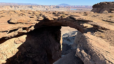
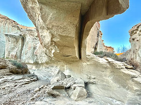
The terrain shifts constantly—open desert gives way to winding slot canyons, layered cliffs, and fragile formations shaped over time. Around Big Water, the landscape feels closely connected to the Vermilion Cliffs region just across the Arizona border, with similar colors and textures carrying through. Farther into the monument, especially near Escalante, you’ll find access to well-known slot canyons and destinations like Calf Creek Falls, where water and desert meet in unexpected ways.

Exploring and Hiking
Exploring this area is less about a single destination and more about how you move through it. Some stops are quick and accessible, like Toadstool Hoodoos, while others invite longer days and a bit of route-finding.
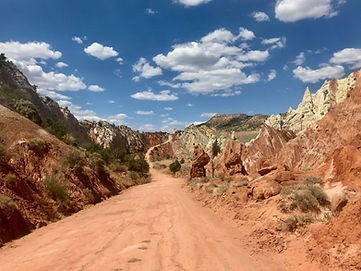
One of the best ways to experience this region is along Cottonwood Canyon Road, which runs between Cannonville and Big Water. The road itself becomes part of the experience, passing through shifting terrain—badlands, narrow canyons, and formations like Grosvenor Arch. Several hikes branch directly from this corridor, including Hackberry Canyon and Cottonwood Canyon, making it a natural place to spend a few days exploring at a slower pace.
Many of the routes near Big Water feel like a continuation of the Vermilion Cliffs landscape just across the Arizona border, making it easy to pair this area with nearby destinations like Vermilion Cliffs and Page/Marble Canyon.


Featured Hikes


Things to Know
This is a remote and varied landscape where conditions can change quickly. Many areas require basic route-finding, preparation, and awareness of weather.
Cottonwood Canyon Road and similar routes can become impassable when wet. The clay surface turns to deep mud even after light rain. Always check current conditions with the BLM before driving.
High clearance is strongly recommended for backcountry roads. Even when dry, rough sections and wash crossings can make travel slow or difficult.
Cell service is unreliable or nonexistent throughout most of the monument. Plan ahead and bring extra water, food, and fuel.
Dispersed camping is widely available, especially along roads like Cottonwood Canyon. Many sites are in scenic, quiet locations—take time to explore side roads and pullouts to find a good spot.
Staying near Kanab, Page or Big Water also puts you in range for the daily Wave lottery, which can be a great addition if you’re spending time exploring this region.


When to Visit
This area is extremely hot in summer and best explored in spring, fall, or winter. Cooler seasons not only make hiking more comfortable but also tend to bring fewer people. Winter can be especially rewarding when conditions are dry, offering quiet and clear light across the landscape.
Where to Stay
For camping, dispersed sites along Cottonwood Canyon Road offer some of the most atmospheric places to stay in the region. The road is lined with pullouts and lesser-used spots, many set within striking desert scenery. It’s worth taking time to find a place that feels quiet and removed. *Look for a particularly special one across the way from Hackberry Canyon, one of the most mystical spots I have ever slept.
For lodging, a simple roadside motel in Big Water makes a convenient and affordable base. Depending on where you’re exploring, Page, Kanab, Escalante, and the towns near Bryce Canyon all offer additional options, with prices often more reasonable outside of peak summer months.